 |  |
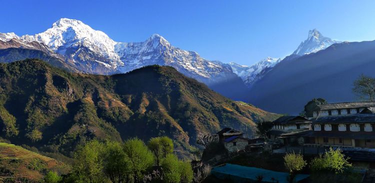
Annapurna I Main (Sanskrit, Nepali, Newar: अन्नपूर्ण) is a mountain and part of the Annapurna massif in the Himalayas in north-central Nepal that includes one peak over 8,000 metres (26,000 ft), thirteen peaks over 7,000 metres (23,000 ft), and sixteen more over 6,000 metres (20,000 ft). The massif is 55 kilometres (34 mi) long, and is bounded by the Kali Gandaki Gorge on the west, the Marshyangdi River on the north and east, and by Pokhara Valley on the south. At the western end the massif encloses a high basin called the Annapurna Sanctuary. Annapurna is the tenth highest mountain in the world at 8,091 metres (26,545 ft) above sea level.
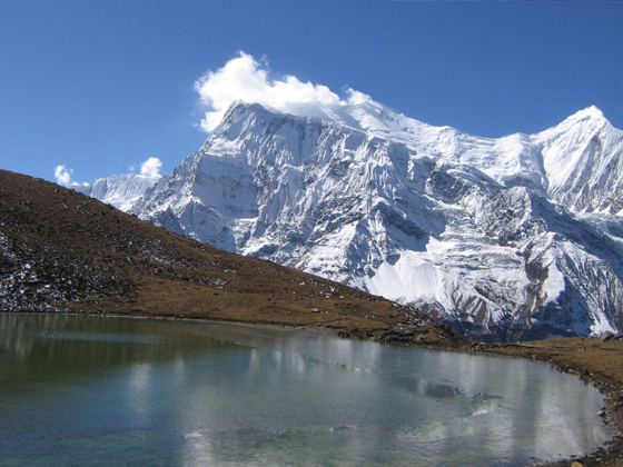
The Annapurna Conservation Area is Nepal's largest protected area covering 7,629 km2 (2,946 sq mi) in the Annapurnarange of the Himalayas across the Manang, Mustang, Kaski, Myagdi, and Lamjung districts. The area ranges in altitude from 790 m (2,590 ft) to the peak of Annapurna I at 8,091 m (26,545 ft).
The Annapurna Sanctuary is a high glacial basin lying 40 km directly north of Pokhara. This oval-shaped plateau sits at an altitude of over 4000 metres, and is surrounded by a ring of mountains, the Annapurna range, most of which are over 7000 metres. With the only entrance a narrow pass between the peaks of Hiunchuli and Machapuchare, where run-off from glaciers drain into Modi Khola River, the Sanctuary was not penetrated by outsiders until 1956. Because of high mountains on all sides, the Annapurna Sanctuary receives only 7 hours of sunlight a day at the height of summer. The unique combination of heights and depths on the 5-7 day trek into the Annapurna Sanctuary give rise to an extraordinary variety of ecosystems. The south-facing slopes are “covered in dense tropical jungles of rhododendron and bamboo”, while the north-facing slopes, in the rain shadow, have “a drier colder climate similar to that of the near-by Tibetan Plateau.” The entire sanctuary was held as sacred to the Gurung people, one of the many native people to inhabit the area. They believed it was the repository of gold and various treasures left by the Nagas, the serpent-gods known in India. The sanctuary was believed to be the home of several deities, from Hinduism and Buddhism as well as older animistic gods. The peak of Machapuchare at the entrance was believed to be the home of the god Shiva.
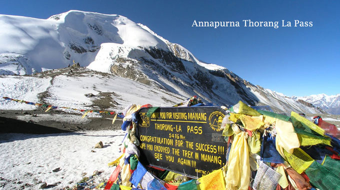
Its famous for Annapurna Circuit. It's a trek within the Annapurna mountain range of central Nepal.[1] The total length of the route varies between 160–230 km (100-145 mi), depending on where the motor transportation is used and where the trek is ended. The trek rises to an altitude of 5,400m on the Thorung La pass, touching the edge of the Tibetan plateau. This trek crosses two different river valleys and encircles the Annapurna massif, crossing Thorung La (5416m), the highest pass on this trek. Practically all trekkers hike the route counter clockwise, as then the daily altitude gain is slower and crossing the high Thorong La pass is easier and safer.The mountain scenery, seen at close quarters includes the Annapurna Massif (Annapurna I-IV), Dhaulagiri, Machhapuchhre, Manaslu, Gangapurna [7455m] and Tilicho Peak(7134m). Numerous peaks of 6000-8000m in elevation rise from the Annapurna range.
The Annapurna Conservation Area is Nepal's largest protected area covering 7,629 km2 (2,946 sq mi) in the Annapurnarange of the Himalayas across the Manang, Mustang, Kaski, Myagdi, and Lamjung districts. The area ranges in altitude from 790 m (2,590 ft) to the peak of Annapurna I at 8,091 m (26,545 ft).
The Annapurna Sanctuary is a high glacial basin lying 40 km directly north of Pokhara. This oval-shaped plateau sits at an altitude of over 4000 metres, and is surrounded by a ring of mountains, the Annapurna range, most of which are over 7000 metres. With the only entrance a narrow pass between the peaks of Hiunchuli and Machapuchare, where run-off from glaciers drain into Modi Khola River, the Sanctuary was not penetrated by outsiders until 1956. Because of high mountains on all sides, the Annapurna Sanctuary receives only 7 hours of sunlight a day at the height of summer. The unique combination of heights and depths on the 5-7 day trek into the Annapurna Sanctuary give rise to an extraordinary variety of ecosystems. The south-facing slopes are “covered in dense tropical jungles of rhododendron and bamboo”, while the north-facing slopes, in the rain shadow, have “a drier colder climate similar to that of the near-by Tibetan Plateau.” The entire sanctuary was held as sacred to the Gurung people, one of the many native people to inhabit the area. They believed it was the repository of gold and various treasures left by the Nagas, the serpent-gods known in India. The sanctuary was believed to be the home of several deities, from Hinduism and Buddhism as well as older animistic gods. The peak of Machapuchare at the entrance was believed to be the home of the god Shiva.
Its famous for Annapurna Circuit. It's a trek within the Annapurna mountain range of central Nepal.[1] The total length of the route varies between 160–230 km (100-145 mi), depending on where the motor transportation is used and where the trek is ended. The trek rises to an altitude of 5,400m on the Thorung La pass, touching the edge of the Tibetan plateau. This trek crosses two different river valleys and encircles the Annapurna massif, crossing Thorung La (5416m), the highest pass on this trek. Practically all trekkers hike the route counter clockwise, as then the daily altitude gain is slower and crossing the high Thorong La pass is easier and safer.The mountain scenery, seen at close quarters includes the Annapurna Massif (Annapurna I-IV), Dhaulagiri, Machhapuchhre, Manaslu, Gangapurna [7455m] and Tilicho Peak(7134m). Numerous peaks of 6000-8000m in elevation rise from the Annapurna range.
